In the world of architecture, engineering, and construction (AEC), there is an old saying: “A project is only as good as its foundation.” But before a single pier is poured or a wall is framed, there is a foundation of a different kind—data.
If you are starting a renovation, a land development project, or a complex infrastructure upgrade, you’ve likely heard the term Existing Conditions Survey. It is currently one of the most researched terms in the industry, and for good reason. Understanding exactly what is on the ground (or in the ceiling) today prevents the “surprises” that lead to change orders tomorrow.
At XZ, we’ve moved beyond the tape measure and tripod. Here’s how we use Reality Capture technology to redefine the standard for the modern existing conditions survey.
What exactly is an Existing Conditions Survey?
At its core, it is a comprehensive map of a site’s current state. This includes architectural features, structural elements, and MEP (Mechanical, Electrical, and Plumbing) systems. Traditionally, this was done with manual measurements—a process prone to human error and “shadow areas” that were missed.
How XZ Uses Reality Capture to Get It Right
“Reality Capture” is the process of digitizing the physical world with millimeter precision. At XZ, we utilize a three-tiered tech stack to ensure your survey is a perfect digital twin of reality:
1. Aerial LiDAR and Photogrammetry (Drones)
For large sites or complex roof structures, we deploy high-end drones. Unlike traditional photography, Aerial LiDAR can “see” through vegetation to the ground surface, providing an ultra-accurate topographic map that is essential for drainage and site planning.
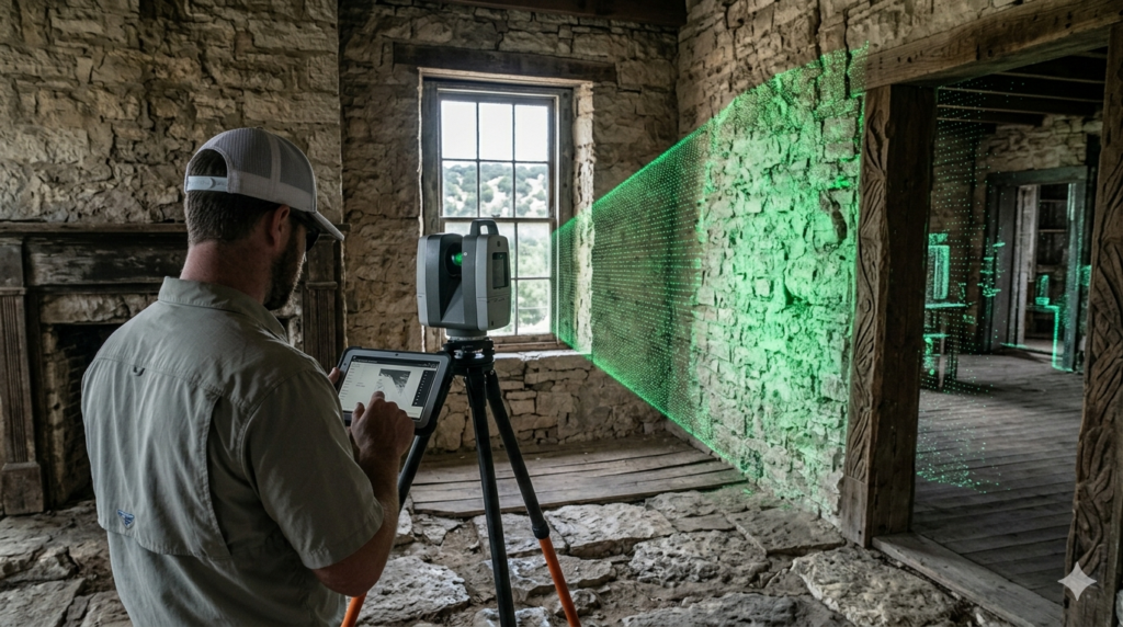
2. Terrestrial Laser Scanning (LiDAR)
Inside a building, we use tripod-mounted laser scanners. These devices emit millions of laser points per second to create a Point Cloud. This allows us to capture the exact “lean” of a historic wall or the precise height of an overhead steel beam—details a manual survey would almost certainly miss.
3. 360° Visual Documentation
We supplement our geometric data with immersive 360° walk-throughs. This allows stakeholders to “visit” the site from their office in Wimberley or anywhere else, inspecting existing conditions without the time and cost of travel.
The Benefits of the Digital Approach
Why choose a reality-capture-based survey over traditional methods?
- Eliminate Rework: Most project delays are caused by “discrepancies” between old paper plans and actual field conditions. We find those discrepancies in the first 24 hours.
- Safety: We can survey high-voltage areas, unstable structures, or busy intersections from a safe distance using long-range sensors.
- BIM-Ready Data: Our surveys don’t just end up as a PDF. We provide data that plugs directly into Revit, AutoCAD, or Civil 3D, allowing your design team to start working immediately on a “source of truth.”
Start Your Project with Confidence
An Existing Conditions Survey shouldn’t just be a checkbox on your to-do list; it should be your project’s greatest insurance policy. By leveraging reality capture, XZ provides the clarity you need to design with precision and build with confidence.
Ready to digitize your site? Contact XZ today for a consultation on your next survey.